Super El Niño Points to a Mild Winter — and Evans Warns of Drought Risk for Next Growing Seasonknown for live severe-weather coverage on Facebook.
Drought Concerns Extend Into Next Growing Season
The dry fall has been a help to farmers, Evans said, noting a recent drive through the state showed cover crops going in and nothing left standing in the fields. Yields, he said, appear down from last year but still decent.
“From what I’m hearing, it wasn’t as good of a year as last year, but still pretty good for most,” Evans said.
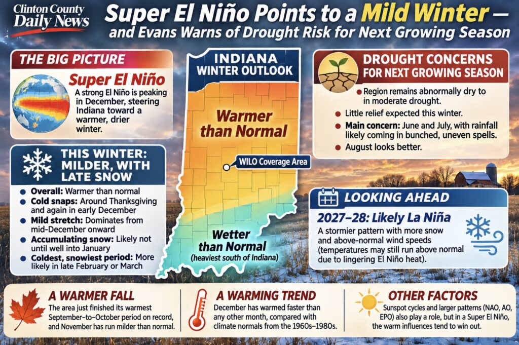
The region remains abnormally dry to in moderate drought, and Evans said he does not expect that story to change much this winter.
“We may get a little bit of brief release, but I do have some concerns,” Evans said. “Even if we get the rain during the spring and it does go above normal for a little bit, I have some drought concerns next summer.”
His worry, he said, is a feedback loop that starts well north of Indiana. Canada is likely headed for a near-record if not record warm winter with little snowpack, and that missing snow cover means soils and air both warm quickly in spring.
“When you don’t have snowpack up there and the soils are already dry in the spring, you warm up pretty quickly here, but also it’s a feedback mechanism,” Evans said. “Without snow, and we warm up fast, well, there’s less moisture.”
Evans said he is most concerned about June and July of the coming growing season, with rainfall likely to come in bunched, uneven spells rather than steady soakers. August, he said, looks better.
A Mild Winter, With Snow Waiting Until Late
The winter outlook itself, Evans said, is straightforward: warmer than normal. A band from California across the Southeast and Mid-Atlantic is expected to run wetter than normal, while Indiana sits north of the heaviest precipitation.
“It’s not to say that we’re not going to get cold weather,” Evans said. “Even in the warmest winters we have on record, we still get down to about zero.”
Evans said to expect a cold snap around Thanksgiving and another in early December, followed by a mild stretch that dominates from mid-December onward. Accumulating snow may have to wait until well into January, and the snowiest, coldest weather of the season may not arrive until late February or early March — a signature, he said, of El Niño winters that weaken as spring approaches.
“You oftentimes get your coldest weather and your biggest snow in March,” Evans said. “I’ve seen some El Niño years where the coldest temperature of the whole winter is in early March.”
The culprit is a Super El Niño — the periodic warming of sea-surface temperatures in the central and eastern tropical Pacific that shifts jet streams and weather patterns around the globe. Strong El Niño events historically steer the Ohio Valley toward winters that are milder and drier than normal, and this one, Evans said, is expected to peak in December before weakening through the spring.
From El Niño to La Niña Next Winter
Evans said he is already looking past this winter to a likely La Niña — El Niño’s cooler counterpart in the Pacific — arriving for the 2027-28 season.
“Typically after a Super El Niño, the heat may linger into the following winter, and then you kind of transition into a La Niña, which is a completely different animal,” Evans said.
That pattern, he said, should bring above-normal wind speeds, a stormier weather pattern and more snow than this winter — though temperatures may still run above normal because of lingering El Niño heat.
Warmest Fall on Record
The mild pattern is not new. Evans noted the area just finished its warmest September-to-October period on record, and November so far has run like a typical month in southern Kentucky — one reason fall color is still hanging on area trees in mid-November.
Comparing 2010-2026 climate normals against those of the 1960s through 1980s, Evans said December has warmed faster than any other month on the calendar, stretching the warm side of fall later into the year.
Sunspots, Patterns and the Long Game
Asked by a listener whether sunspot cycles factor into his forecasts, Evans said they do. Periods with few sunspots, he said, show a strong correlation with colder winters and cooler summers, citing the Maunder minimum of the 1600s that coincided with the “Little Ice Age.” Active solar cycles tend to run warmer overall.
He describes his long-range method as looking for the “dominant player” among large-scale patterns such as the North Atlantic Oscillation, the Arctic Oscillation and the East Pacific Oscillation — and in a Super El Niño, he said, the warm players tend to overrule the cold ones.
Where to Follow the Forecast
Evans publishes short-, medium- and long-range forecasts daily on Substack, with updates at 6 a.m. and in the afternoon, plus a weather app and live Facebook coverage during severe weather. He also posts a weekly feature on native Indiana trees — currently working through the oaks — a project that grew out of his FFA forestry and wildlife management days.
His forecasts and severe-weather updates are part of the local weather picture alongside WILO’s own weather coverage during regular programming and emergencies. Listeners can hear “Party Line” on WILO and Boone’s Best 102.7.