The Town of Zionsville has announced that effective Sept. 1, the Zionsville Police Department patrol boundaries will be expanded to cover new areas throughout the town and Boone County.
The town stated that beginning Sunday, Sept. 1, the new patrol boundary to the north of the town will extend to County Road 300 South, which includes Brookhaven to the county line. For the southern boundary, the department will patrol to the Boone County and Marion County line. For the eastern boundary, the department will patrol to the Boone County and Hamilton County line. For the western boundary, the department will patrol up to County Road 800 East from County Road 300 South to Oak Street and west to Interstate 65.
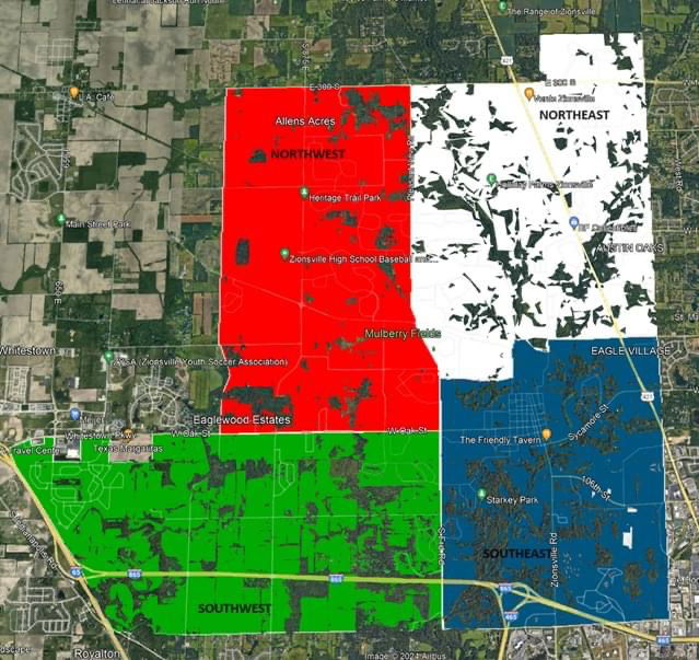
The new patrol boundaries will be divided into multiple districts, including:
- Northwest District
- Northern Boundary: County Road 300 South
- Southern Boundary: Oak Street
- Eastern Boundary: Ford Road/Pleasant View Road
- Western Boundary: County Road 800 East
- Northeast District
- Northern Boundary: County Road 300 South as well as Brookhaven to county line
- Southern Boundary: Bloor – Mulberry – Turkey Foot – Temple – Willow – Templin
- Eastern Boundary: Hamilton County line
- Western Boundary: Ford Road/Pleasant View Road
- Southwest District
- Northern Boundary: Oak Street/Whitestown Parkway
- Southern Boundary: Marion County line (96th Street)
- Eastern Boundary: Ford Road
- Western Boundary: I-65
- Southeast District
- Northern Boundary: Bloor – Mulberry – Turkey Foot – Temple – Willow – Templin
- Southern Boundary: Marion County line (96th Street)
- Eastern Boundary: Hamilton County line
- Western Boundary: Ford Road